Ignacio Sepúlveda
SDSU Coastal Engineering
Sensing Technologies: Existing techniques and innovation
GNSS Interferometric Reflectometry (GNSS-IR) studies for the measurements of coastal water levels and waves (current work)
During the summer 2019, we initiated our experiments at the Ellen Browning Scripps Memorial Pier. We measure coastal sea levels and wave height by means of GNSS reflections. We have complete our first experiment, dataset, and processing codes. Now we are carrying out new experiments. For example, we measured hurricane storm surge. We are also incorporating the GNSS-IR technique in smartphones, so everyone can measure the sea!


Left above: Picture of the experiment setup at the Ellen Browning Scripps Memorial Pier during August 2019. Right above: A comparison of GNSS-IR water levels (Hr, top) and significant wave height (Hs, bottom) measurements using GPS, GLONASS and Galileo constellations and traditional tide and wave gauge records (blue continuous lines). The tide and wave gauges are located next to the GNSS antenna. GNSS-IR RMS errors of 9 cm and 13 cm are achieved for water levels and wave measurements, respectively.
Right: Storm surge measurements during Hurricanes Paulette and Teddy at Bermuda Island using an existing GNSS geodetic antenna of the NOAA CORS Network freely available online. Measurements were validated with a tide gauge record next to the GNSS station.
Below: Smartphone and GNSS geodetic antenna co-located at Scripps Pier. Time histories show the corresponding SNR for some satellites (raw data used by the GNSS-IR technique) and sea level measurements. Deployments by Bing Cao (UCSD)


Social media videos and citizen science revealing enigmatic tsunamis
With my supervisor Dr. Jennifer Haase and other collaborators from Chile and Singapore, we identified the source of the tsunami in Palu bay during the September 28th, 2018 strike-slip earthquake. We propose a new inversion method which take full advantage social media videos collected from Youtube and Twitter. Our results indicate that the tsunami was mainly generated by landslides. A poster was presented in AGU Fall Meeting 2018, a co-authored paper was published in March 2019 in Geophysical Research Letters and a second paper is published in JGR: Solid Earth.

Left: (a): Results of a landslide-generated tsunami source inversion for sources initiating at times 0, 20, 40, 60, 80 and 100 seconds, due to possible landslides. The propagating waves from the source are linearly superposed with the propagating waves from previous time steps. The letters indicate the source locations and the numbers indicate the locations of video-derived (cellphones and CCTV cameras) tsunami time histories used to constrain the inversion (presented in c). Location 8 is the same as 5. The errors and regularization of the inverted results are shown in the top left corner. (b): Comparison of runup measurements with the forward model using the resulting modeled landslide sources (black dots). The forward models which include the combined landslide sources and coseismic deformation contribution of the twelve earthquake models are shown as grey dots, nearly indistinguishable on this scale. (c): Comparison of the video-derived time histories (red curves) and the tide gauge (blue curves), the inversion results (green curves), the forward model with landslide sources (black curves) and forward models with landslide sources combined with the coseismic contribution from twelve earthquake models generated in our study (grey curves). All time histories have been de-tided.
Synthesis of ocean bottom pressure sensors to capture relevant properties of earthquakes (current work)
Ocean bottom pressure sensors (e.g. in OBS) located close to potential earthquake rupture areas promise to reveal new information about large earthquakes in subduction zones right after an earthquake occurs (~minutes). This information may be useful to characterize relevant properties of earthquakes and, furthermore, provide a better estimation of tsunamis before they arrive to coastal communities. In this study we aim to isolate relevant signals of OBS records and relate them with earthquake and tsunami characteristics.

Wavelet analysis of real ocean bottom pressure sensor records for a large earthquake. The sensors are closed to the earthquake rupture area (distances < 400 km). Stations over the rupture area (e.g. P02) contain significant energy in the period band 1 to 10 seconds. These signals are most likely related to body waves of the earthquakes. These waves arrive very fast to the stations. Further stations (e.g. NMS05) do not seem to capture body waves. Apparently these waves are attenuated at short distances. Instead, a strong signal content arrives at later times, with periods >10 seconds. The latter signals may be associated with seismic surface waves. Most of the stations (P02, P03, P08, P06, P07, P09, GJT3) show a significant content for periods of ~10 min. This content is most likely related with a tsunami wave generated with the earthquake. Further properties are expected to be extracted from this type of records.
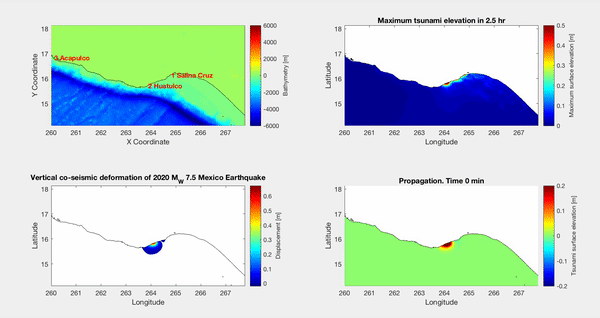
Studying earthquakes and tsunami with InSAR inversions.
During my postdoc I mastered my knowledge of exploiting InSAR data to estimate the characteristic of past earthquakes and generated tsunamis. I use the code GMTSAR. InSAR inversions have been applied for the 2018 Palu earthquake and the 2020 Mexico earthquakes and tsunamis.


Right: Co-seismic ground deformation from the 2020 Mexico Earthquake as measured by two passes of Sentinel satellite and processed using GMTSAR. Below: Tsunami simulation using the seafloor deformation. The animation shows the propagation of edge waves through the Mexican coast.